August 3rd: I arrived at Colorado National Monument the evening before, not having time for much sightseeing. In the morning, I looked around a bit and took the following photos.
Monument Canyon includes Independence Monument, a 450′ tower of soft red sandstone:

Independence Monument
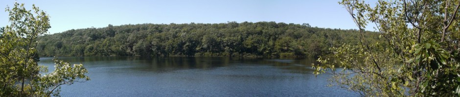
A broader view of Monument Canyon, from a different angle:

Monument Canyon
:

Red Canyon Overlook
I was only there for a few hours. Looking back, I wish that I had done more hiking (and photography).
8-3-94
Dear Mom,
Left Col. Nat’l Mo. this a.m., in nearby Grand Junction, population 35,000, got glasses fixed for free by Pearle, got car’s oil changed, got 2 pair of 40% wool, 60% acrylic socks @ WalMart. Arrived @ Black Canyon of the Gunnison Nat’l Mon. Another canyon which I find inferior to Canyonlands. I didn’t find postcards here, so I don’t know if I’ll write more. Pit toilets at these parks have seats, but don’t flush. $7 for this campsite with pit toilet & water only @ visitor center, vs. free for Canyonlands with no water anywhere, $8 @ Mesa Verde with real toilets & showers available. I.e., totally inconsistent fee structure. Tonight am camped @ 8200′. As when I camped Sunday night @ this altitude, I can breathe o.k., but it is colder @ night, so either it’s colder everywhere tonight, or it’s due to the altitude. So 12,000′ will be interesting. Suggested acclimation was in Aspen or campground there @ 8000′ or below, so I’m already used to that, & don’t need to go to Aspen early.
In 1999, Black Canyon of the Gunnison was elevated to national park status. I don’t really understand how the Park Service (or Congress) decides which park is worthy of that status vs. being a national monument. Perhaps if I had seen Black Canyon first I would have loved it, but seeing it right after I had been to Canyonlands and Arches, I was not impressed. I did not take many photos here, and only one is somewhat presentable:

Black Canyon of the Gunnison National Monument
August 4th: Not having any particular goal, I drove in a large square: east on U.S. Route 50 to Pueblo, then took U.S. Route 87 to Colorado Springs, I-25 to Denver, and then I-70 to Glenwood Springs, then Highway 82 south to Aspen.
As I noted, one of my main objectives of the trip out west was to join the Sierra Club for a week as we performed trail maintenance. We planned to camp around 10,000′ and hike and work above that, up to 13,000′, so we had been told to arrive early and acclimate to the altitude. As I’ve noted earlier, I had spent a few nights without trouble at 8200′. We were instructed where to meet the team, at a campsite near Aspen, and I likely arrived there the night of August 4. Unfortunately, I don’t seem to have a record of which campsite we met at, the names of the other participants, etc.
August 5th: I drove back to Glenwood Springs. One spot that I noticed the previous day that I wanted to visit was Hanging Lake. It was a very pretty spot with a parking lot and trailhead just north of I-70 (and only reachable from the westbound lanes). The trail climbs 1000′ over the course of 1.2 miles, to a small lake on a plateau:

Hanging Lake
:

Hanging Lake
At nearby Glenwood Springs, I visited Pioneer Cemetery, where Doc Holliday is buried. While he is somewhere in the cemetery, the exact location is unknown. He is not necessarily beside this memorial marker:

Tombstone of Doc Holliday
I then returned to the campground outside of Aspen.
8-5-94
Dear Mom,
Just got cut off by the telephone. I guess it was on a timer. I’m afraid my long-distance phone calls will cost more than the rest of the trip. The leader, cook, trainee, & another group member were going to our campsite today, but I elected instead to backtrack about 50 miles to a place I passed yesterday calling Hanging Lake. It would have been too dark to see yesterday. I guess I’ll call on the 16th?
From my postcards and letters, I believe that the Sierra Club trip ran from Sunday, August 7th through Monday, August 15th (or Tuesday, August 16th).
8-6-94
Dear Mom,
I still haven’t met many of the campers. Only the leader, cook, trainee, & two participants. The others are staying in motels or flying in today. It seems strange to me that people who like camping would stay in expensive motels. Now I’m doing laundry. In Aspen, the laundromat was too expensive, & I had to go to another town to look for some supplies, so I found a laundromat where a wash is $1 & dryer $0.25 for 10 minutes. In Aspen it was $2 wash and 25¢ for 5 minutes of drying! I thought Aspen would be empty this time of year, but it is full. They are having a music festival, but it’s probably full all the time.
At Mesa Verde it rained & my jacket & hat worked well, but the leader thinks I should have rain pants also. I stopped in a store called Factory Surplus which had all sorts of outdoor clothing & supplies, but not cheap. They had rain pants for $18. At Mesa Verde my tent was wet inside, but I hadn’t closed the outer flap, so I didn’t know if it leaked, or if the water came through the netting. Yesterday afternoon it rained hard & the tent was very wet inside, which I emptied using my towel. I was not amused. The campers seem sort of snobby against my frugal ways. One, a lawyer, suggested I buy a new tent. The leader suggested a tarpaulin to hang over my tent, as it lacked a rain fly. I think the tent documentation said that some seams might need to be sealed, but I don’t know if this is sealable. Considering that tents are made to be used outdoors & that it rains outdoors, I don’t know how they can sell a tent that leaks so much. So I stupidly drove to WalMart, which is about an hour north of Aspen, looking for a tarp & maybe sealant too, & arrived at 9:15, after they had closed. So I wasted a lot of gas. So last night it rained again, though maybe not as hard, & I sponged the water up every few minutes. It’ll probably rain every day here.
I saw pictures of our campsite & work area. There is still snow there that hasn’t melted! There is a lake there, but I think it’s fed only by melting snow, so it probably wouldn’t be fun to swim in it. (I was thinking of resources for bathing.) The only good news (to me) was the leader complained that the trail we were supposed to fix looked fine the way it is, & he doesn’t think we’ll be too busy. I’m already concerned I won’t enjoy this.
. . .
I hiked to Hanging Lake, a small pond high up a mountain which is fed by a few waterfalls. It was nice, but a very hard hike uphill. Coming down was easy, though. At least I know from that hike and from my hike at Arches with the ranger, that my boots are comfortable & don’t give me blisters. My sleeping bag & pad are o.k. I hope my backpack will be o.k. So maybe my tent will be the only problem. I hope my thermal underwear & sweatshirts will keep me warm enough. They probably will, as it probably will be in the 40’s at the coldest.
* * *
I was in between jobs and trying to be frugal. Twenty years later, my views have changed somewhat. I understand that people who enjoy camping may still only want to rough it for a few days, with the rest of the time spent in comfort or even in luxury. I also understand the importance of having good gear that is functional and comfortable, and if possible lightweight. I also understand that almost all tents require sealing of the seams after purchase (with a few exceptions). — I can still be frugal at times, though, and hope that I don’t look down on others who are being frugal.
Luckily we didn’t have to worry too much about weight. Other than carrying some water for the hike in, water was plentiful in the mountains, as long as we treated it. And we were escorted in by pack animals that carried our food and cooking equipment. So I only had to carry my tent, sleeping bag, sleeping pad, and clothing. — And of course my camera.
August 7-15: I did manage to obtain a tarp before we began our hike into the Collegiate Peaks Wilderness of White River National Forest. We arrived and set up camp. I believe that we were camping at around 10,000′. One of the campers actually did become sick, and the leader phoned it in, and mountain rescue arrived later that evening and took him to a lower altitude. The rest of us were fine. Here is my campsite, with my cheap tent and the tarp to keep it dry:

Campsite in Collegiate Peaks Wilderness
We were working on the Grizzly Lake Trail, appearing in the photo below as a very slender ribbon in the lower left of the photo:

Grizzly Lake Trail
The trail climbs to Grizzly Lake, at 12,500′. (The trail does not go to the top of Grizzly Peak, at 13,988′.)

Grizzly Lake
A mining town named Ruby had once flourished nearby, but little was left now:

Overlooking the Mining Ghost Town of Ruby
The mountain scenery was beautiful:

Mountain scenery
:

Fog Rolling Over the Mountains
As I mentioned above, the trail was in decent shape, so we were not doing a huge amount of work. We put in a few water bars to prevent trail erosion, fixed a few areas of the trail that had been eroded, and erected a number of cairns. Here, one of the group stands next to a cairn. As you can see, this is above the tree line, and cairns are helpful to identify where the trail is. They are especially important during snow season, when the ground is covered and one can’t follow the trail just by looking for the ribbon of dirt that is not covered by grass:

Cairn construction
We also worked on a retaining wall in one area. I’m sure that I worked a bit also, when I wasn’t taking photographs:

Retaining wall construction
More of the Sierra Group volunteers working on the Grizzly Lake Trail:

Grizzly Lake Trail maintenance
Back at the campsite, I photographed a deer who was visiting nearby:

Deer at Campsite
We didn’t have to work that hard on the trail, and at least one day was given over to hiking without our tools:

Hiking in the Collegiate Peaks Wilderness
I believe I’m seated at right in this photo, with the green hat. I wish I knew our elevation here:

Sierra Club Trail Maintenance Team
Another beautiful view:

Collegiate Peaks Wilderness
Here’s another long-distance photograph of myself:

Charlie at Collegiate Peaks Wilderness
And another closer view:

Charlie at 13,000′
The mountains were beautiful at every time of day:

Moonrise
Aug. 16th or 17th: I’m guessing as to the date, but the Sierra Club trip probably ended on the 15th or 16th, at which point I drove to Great Sand Dunes National Monument, now Great Sand Dunes National Park and Preserve. It was elevated to National Park status in 2000, and the government purchased more property surrounding the park, tripling it in size. I can see this one being worthy of National Park status, as it includes the tallest sand dunes in North America, which began forming less than a half million years ago, according to researchers. The highest dunes are 750′. The floor of the San Luis Valley is 7664′, and the park includes six peaks over 13,000′, including Kit Carson Mountain at over 14,100′.

Great Sand Dunes National Monument
This was my first experience with significant sand dunes (other than very low ones along the shore of the Atlantic Ocean). I loved the way the shadows play over the sands:

Great Sand Dunes National Monument
The surrounding mountains were beautiful, and also contributed to the development of the dunes themselves. Sand from the Rio Grande and its tributaries passed into the San Luis Valley. The waters evaporated and westerly winds carried the sand particles eastward, but the winds were only strong enough to carry the particles to the eastern edge of the valley. Thus, the dunes began to form, and the process continues today.

Great Sand Dunes National Monument
:

Great Sand Dunes National Monument
Grass, flowers, sand dunes, a mountain range, and blue skies! It was a beautiful place to visit:

Great Sand Dunes National Monument
After visiting this park, I began my drive back to Florida, having enjoyed a wonderful trip out west.