This park, donated by the Ordway family and formally called Lucius Pond Ordway Devil’s Den Preserve, received that name because a charcoal maker working in the area had seen what appeared to be a hoof mark made in a boulder, and decided that it was the mark of the Devil.
There are no mountains, but there are many hills, and it is a very pretty place, with much greenery, bare rock, several stone walls, and brooks and streams running throughout. The bulk of the park is in the Town of Weston, with three small parcels (only two having trails) jutting across the border with the Town of Redding. In addition to 20 miles of trails within the park, a few trails connect to property outside the park, including Arthur F. Brinckerhoff Nature Preserve, which has an additional 3 miles of trails, and the Bruzelius Trail, which has another 3.2 miles of trail.
Driving through Weston is nice, as it’s an affluent area. After turning off a main road, my GPS directed me into a series of turns on winding residential streets. While there were older, smaller homes, there were also newer mansions.
At the parking area inside the park, I picked up a brochure with a trail map from the kiosk. The preserve’s website had included a 2012 map, which I had printed out at home, but I found that the trail map in the kiosk included a few features that were missing from the Internet map. The park has an unusual blazing system whereby main trails (woods roads) are blazed red, while footpaths are blazed yellow. So if many paths have the same color, how does one know where he is? Each intersection has a post that is numbered, and the numbers are also shown on the map. Each intersection also includes an arrow showing the shortest route back to the parking area.
The park is popular, and over the course of the day I saw many people there. A few were carrying small packs, but most were not carrying water or anything else, and I did not see anyone else with a map. I suspect they were all locals who knew the park well.
I started out on the red-blazed Pent Trail, but quickly turned onto a footpath, the yellow-blazed Deer Knoll Trail. This reached another junction, and I turned onto the Hiltebeitel Trail.
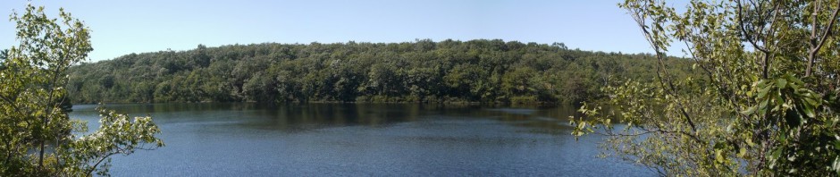
11:04 a.m.: The map showed a number of vistas in the trail, and I visited them all. As I mentioned, there are no mountains, so there were no spectacular views, and in most cases foliage prevented a clear view from the vistas.

Vista on Hiltebeitel Trail
11:11 a.m.: An interesting assortment of trees, bare rock and greenery:

Bare rock
11:18 a.m.: More bare rock:

More bare rock
11:25 a.m.: Green!

Ferns

Vine
11:36 a.m.: The Hiltebeitel Trail reached a junction and turned into the Sap Brook trail, which ran parallel to Sap Brook for a while. A group of six young women who had been trailing me and making a lot of noise finally passed me. They had a mid-sized cream dog with them, which they called Gator. I guess they didn’t notice the two signs that said that pets were not allowed. At least Gator did not bark at me.

Sap Brook
11:46 a.m.:

Sap Brook
12:16 p.m.: The Sap Brook trail led back to the Pent Trail. I followed that for a very short while and then turned onto another footpath, the Ambler Trail, where I photographed this rock wall:

Rock wall on Ambler Trail
12:27 p.m.: I reached another vista, this one on the Ambler Trail. One can make out a bit of a distant ridge line, through the leaves of nearby trees:

Vista on the Ambler Trail
12:36 p.m.: Leaving the Ambler Trail, one passed through Ambler Gorge, which had Ambler Brook running through it. This is a very poor photo of the gorge, which was a pretty spot.

Ambler Gorge
The Ambler Trail took me back to the red-blazed woods road. The map shows that it is no longer called Pent Trail at the point, but rather Den Trail. I followed this north, and it became the Bedford Trail. I continued on this for quite a while, finally turning onto the Deer Run Trail.
1:23 p.m.: Soon after taking this photograph, I stopped for lunch.

Deer Run Trail
1:53 p.m.: The Deer Run Trail led me to a footpath, the Great Ledge Trail, where I photographed this chipmunk:

Chipmunk
1:55 p.m.: I arrived at the only vista that provided a clear view.

Vista on Great Ledge Trail
1:59 p.m.: Backtracking on the Great Ledge Trail, I spotted the remains of a robin’s egg:

Robin eggshell
The next footpath was the Dayton Trail. This led back to a woods road, called Godfrey Trail.
2:33 p.m.: There were several stone walls in the park:

Stone wall on Godfrey Trail
Of historic interest was this portable sawmill and ancient foundation. This equipment is over 100 years old, so it is remarkable that it is as intact as it is. A sign explained that lumbermen found it easier to bring a portable sawmill into the woods and plank lumber there, rather than haul logs out of the woods for processing elsewhere. This photo shows a huge boiler (with steel plates about 1/4″ thick, explaining why it has not rusted to nothing) and a flywheel attached to a piston.

Portable sawmill
The foundation for a small shed:

Shed foundation
A close-up of the flywheel/piston combination:

Flywheel/piston
3:08 p.m.: Nearing the end of my hike, I encountered Godfrey Pond.

Godfrey Pond
3:23 p.m.: On the Laurel Trail, a fallen tree provides some nice texture (with the HDR treatment):

Fallen tree
Minutes later, I returned to the parking area. I estimated that the total hike was 8.1 miles, which took me almost 5 hours.